24 Jan, 2026
3 min read
Tropical Depression Wilma Brings Heavy Rains Across Visayas and Southern Luzon
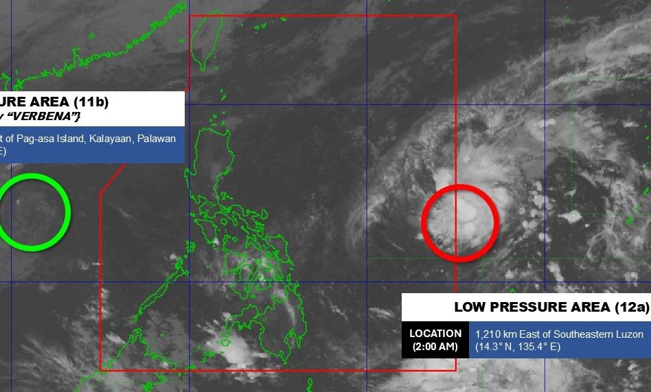
Tropical Depression Wilma is forecasted to make its initial landfall over Eastern Samar or Northern Samar on Saturday, December 6, while producing significant rainfall across the Visayas and Southern Luzon. As of 10 a.m., Wilma was located near the coastal waters of Sulat, Eastern Samar, advancing slowly westward toward land.
The tropical depression continues to maintain maximum sustained winds of 45 kilometers per hour with gusts reaching 55 km/h. The Philippine Atmospheric, Geophysical, and Astronomical Services Administration (PAGASA) reported in its 11 a.m. advisory that Wilma is likely to remain a tropical depression while crossing the Philippine landmass.
Wilma is projected to move through the Visayas region until Sunday, December 7, before reaching northern Palawan by the morning of December 8. However, there is a growing probability that Wilma will weaken into a remnant low over the Visayas due to the influx of cool, dry air from the northeast monsoon (amihan), which typically suppresses tropical cyclone intensity.
PAGASA's latest rainfall outlook indicates that while fewer provinces are under threat, moderate to heavy rainfall is still expected with flooding possible. From Saturday noon to Sunday noon, areas such as Sorsogon, Masbate, Romblon, and Northern Samar may experience heavy to intense rainfall totaling 100 to 200 millimeters. Other provinces including Eastern Samar, Samar, Biliran, and several parts of Panay Island are forecast to receive moderate to heavy rain.
By Sunday noon to Monday noon, moderate to heavy rainfall will shift to Occidental Mindoro, Oriental Mindoro, Romblon, and Palawan.
Meanwhile, Signal No. 1—indicating strong winds—is still in effect for select provinces in Luzon and the Visayas, including Sorsogon, Masbate, Northern Samar, Romblon, and parts of Mindoro and Palawan. Although Signal No. 1 has been lifted for Mindanao and some Visayas areas, gusty winds caused by Wilma and the northeast monsoon persist across much of Luzon and Visayas.
Maritime conditions remain hazardous with very rough seas reaching up to 5.5 meters along northern and eastern seaboards of Catanduanes, Albay, and Northern Samar. Rough to moderate seas are also anticipated around Batanes, Babuyan Islands, Ilocos Region, and Palawan coasts, posing risks to small vessels.
Wilma marks the 23rd tropical cyclone to enter the Philippine area of responsibility in 2025 and the first of December. PAGASA anticipates one or two additional tropical cyclones may impact the country before year-end.
In addition to Wilma, a shear line is producing heavy rainfall over Southern Luzon, extending to Northern Luzon in the coming days. This atmospheric boundary forms where cold air from the northeast monsoon converges with warm easterly winds from the Pacific Ocean. Areas such as Camarines Norte, Camarines Sur, Catanduanes, and Albay are experiencing intense rainfall, raising concerns over possible flooding and landslides.
Residents and local authorities in affected regions are urged to remain vigilant and adhere to safety advisories as adverse weather conditions continue to impact many parts of the Philippines.
Recommended For You

NAPOLCOM, IBP, and PNP Forge Agreement to Enhance Legal Training for Police Officers
Jan 24, 2026
Christine Reyes

DigiPlus Interactive Plans Soft Launch in South Africa by Early 2027
Jan 24, 2026
Katrina Mercado

Samantha Lo and Jannica Rubin Announce Engagement After Nine Years Together
Jan 24, 2026
Angelica Bautista

Dar Global Partners with Trump Organization on Maldives Luxury Hotel Ahead of Saudi-U.S. Summit
Jan 24, 2026
Christine Reyes
